Connectivity is critical not just for accessing information but for requesting transportation in real time and communicating during an emergency. This study provided independent mapping and analysis of cellular coverage on Bainbridge Island. It supported the City of Bainbridge Island in its planning and disaster-preparedness work, as well as support Kitsap Transit, whose buses rely […]
Read More… from Kitsap Transit Digital Inclusion Project
The City of Bainbridge Island is embarking on an update to its Winslow Master Plan. Student work supported the Master Plan update by gathering background information and analyzing existing conditions and trends. Specifically, students reviewed the history of the Winslow Master Plan study area with a comparison to the Winslow Sewer Area. Additionally, students provided […]
Read More… from Winslow Master Plan Background Research and Planning Assistance
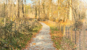
The project focused on creating an inventory of all current park and trail locations and associated resources, including equipment. Students mapped the city’s trails and created a series of maps and/or infographics to depict trail locations and assessments of trail conditions. Students worked with available GIS data and set up the data for use by […]
Read More… from Sultan Parks and Trails Initial Inventory and Assessment
The city’s mission is to improve the lives of the people they serve, and its vision is to be the community of choice for residents, businesses, and employees. Additionally, the city’s Strategic Plan and Balanced Scorecard are designed to drive performance throughout the organization towards one common objective – improving the community experience. The results […]
Read More… from Multi-Generational Community Engagement (2/2)
Choosing viable transportation options for everyday activities is a big step in decreasing an individual’s carbon footprint and leading a more sustainable lifestyle. Every day, people opt to use public transit, ride a bicycle, or carpool to decrease their carbon footprint. In many cases, though, an individual’s ability to practice sustainable transportation can only be […]
Read More… from Transit Circulator Best Practices (1/2)
There is no excerpt because this is a protected post.
With the Eastside Rail Corridor providing a regional, north-south, non-motorized connection through the city; the Mountains to Sound Greenway running east-west; the completion of the 520 Trail; and the I-90 Trail, along with other trail connections throughout the city, there is great opportunity to better define the role of adjacent development in activating these trails […]
Read More… from Recommendations for Trail-Oriented Development along the Wilburton Segment of the Eastside Rail Corridor Trail
This project would complement the Pierce Transit High Capacity Transit feasibility and design study by working with local businesses and residents within a walk distance of two key intersections along the Pacific Avenue corridor at S 38th and S 56th, to explore place-making strategies that could be implemented in conjunction with transit station construction and […]
Read More… from Revitalization Area Planning Toolkit