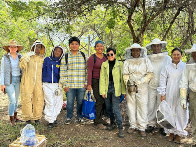
A principios de 2023, profesores de la Universidad de Colima iniciaron un proyecto destinado a categorizar diferentes tipos de miel de Colima. Este proyecto comenzó en el 2015, cuando el equipo de la Universidad de Colima comenzó a buscar financiamiento para el estudio de la flora polinífera y nectarífera del estado de Colima. Estos estudios […]
Read More… from Ayudando a los Apicultores de Colima
Like many other African cities, Lusaka is facing rapid urbanization and various challenges related to inequality, climate change, economic opportunity, and service delivery. The city is faced with limited technical capacity to deliver essential services to all 3.3 million people and with a growth rate of about 5% annually, Lusaka’s Local Authority is unable to […]
Read More… from Lusaka’s Expanding EPIC Partnerships Look to Solve Capacity Issues
This project was completed as part of the 2018-2019 Resilient Communities Project (rcp.umn.edu) partnership with Ramsey County. Ramsey County wanted to assess the accessibility for visitors and clients of County-owned service facilities to make informed decisions about future capital investment in or relocation of these facilities to better meet the needs of the public. Ramsey […]
Read More… from Putting Residents First: Accessibility of County Service Facilities
This project was completed as part of the 2017-2018 Resilient Communities Project (rcp.umn.edu) partnership with the City of Ramsey. Ramsey is fortunate to have several public parks for residents to use, but not all residents have the same level of access to these parks. Students in Dr. Mae Davenport’s Sustainable Land Use Planning and Policy […]
Read More… from Connecting Ramsey (City-Wide Greenway Plan)
This project examined households in the city of Seaside which have received rebates for purchasing water-saving appliances. The goal of this project is to see which income levels make a household more likely to purchase a water-saving appliance with a rebate and whether or not distance from a major retailer has an effect on said […]
Read More… from Water Savings Devices versus Income in the City of Seaside
The study of Seaside storm drain densities between commercial and residential areas is of value because storm drains can be an entry point for trash to collect into a marine sanctuary such as the Monterey Bay. Various geospatial datasets were created and manipulated to create ArcMaps, graphs, and tables to compare storm drain density between […]
Read More… from Storm Drains in Seaside
The study of Seaside storm drain densities between commercial and residential areas is of value because storm drains can be an entry point for trash to collect into a marine sanctuary such as the Monterey Bay. Various geospatial datasets were created and manipulated to create ArcMaps, graphs, and tables to compare storm drain density between […]
Read More… from Traffic Accident Densities
The purpose of this project will be to Geocode Accident data recorded from the City of Seaside Fire Department from March 15th to March 24th. This will allow them to see where these accidents are occurring throughout the city and to determine if the majority of accidents are occurring more in residential areas or near […]
Read More… from Traffic Accident Geocoding
The purpose of this project is to determine the location of restaurants in Seaside and distinguish which ones have passed inspection from the city for the year 2010-2011. The city inspected whether or not they were dumping large amounts of grease in the local sewage system. Due to the fact that large amounts of grease […]
Read More… from Fats, Oils and Grease, Inspections and Restaurants