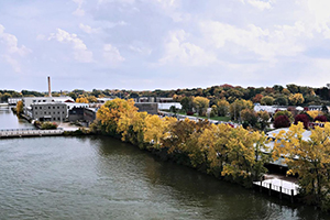
Geography students learned about the sustainability features at the Appleton International Airport and created a video, infographics, social media templates, and photos that highlight the terminal’s skylights, solar panels, biofiltration basin, and the net-zero energy private terminal. Video link: https://mediaspace.wisc.edu/media/UCY+Appleton+Airport+Sustainability+Video/1_acn8z8t8 UniverCity Year Contact Info: UniverCityAlliance@wisc.edu […]
Read More… from Developing marketing materials and video to showcase Appleton Airport’s sustainability for Northern and Central Wisconsin air travelers
This project resulted in revised communications materials outlining the educational programs, outdoor recreation opportunities, and biodiversity efforts available at Mosquito Hill Nature Center. UniverCity Year Contact Info: UniverCityAlliance@wisc.edu […]
Read More… from Creating outreach materials for Mosquito Hill Nature Center
To meet the needs of the nonprofit Friends of Koshkonong Creek, students improved the group’s website to better communicate with stakeholders about the long-term vision for creek conservation. UniverCity Year Contact Info: UniverCityAlliance@wisc.edu […]
Read More… from Developing an initial website for the Friends of Koshkonong Creek
The urban greening and renewal of a city requires the cooling effect of new trees. This prerequisite affects the development of green rooftops and rooftop gardens and the efficiency of water usage across city parks and public facilities. With this understanding, this report proposes to enhance the population of trees across the City of Lemon […]
Read More… from City of Lemon Grove Tree Planting Initiative
Hazardous chemicals used in traditional dry-cleaning methods pose a serious threat to population health when spilled or discharged illegally into the environment. Children, the elderly, individuals with certain medical conditions, or those living in disadvantaged communities are at even greater risk. San Diego State University students collaborated with the San Diego Regional Water Quality Control […]
Read More… from Identification of High-Risk Dry Cleaning Sites in San Diego County: Spatial Analysis
A student created a visual of where nitrogen levels are worse within the community so that actions can be taken in the right areas to increase water quality. UniverCity Year Contact Info Gavin Luter Managing Director gavin@cows.org 608-261-1141 […]
Read More… from Mapping Nitrate-N contamination of groundwater in Marathon County
To combat the intense winter weather of Northern Wisconsin, road salt has been usedthroughout Marathon county as a cheap, effective means to melt snow and ice on roads, keepingdrivers safe in potentially treacherous conditions. Recent discovery has revealed that this roadsalt application has potentially significant consequences on local ecosystems near roads. Ourgoal of this project […]
Read More… from Mapping winter road salt use and sensitive areas in Marathon County
This Democracy in Action project is a California State University San Marcos (CSUSM) initiative program that the Geography 450 Parks and Protected Areas (GEOG 450) class participated in during the spring 2020 semester. The class collaborated with the City of San Marcos (the City) Department of Parks and Recreation (P&R) to initiate a survey of […]
Read More… from Parks and Recreation User Survey (Spr 2020)
As part of a semester-long study, two sections of Geography 354: The Geography of Cities, participated in the Sage Project. The Sage Project is a collaboration between San Diego State University (SDSU) and the city of National City to engage students and fac-ulty in assisting local governments with projects that enhance the city’s economy, land-scape, […]
Read More… from Analysis of National City’s Neighborhoods and Functional Zones
The land use plans outlined in this report were created through the partnership between National City and the SDSU Sage Project during the fall of 2013. Upper-level undergraduate and graduate students in the Geography 572 course titled “Land Use Analysis,” taught by professor Diana Richardson, were given a project site in the National City Marina […]
Read More… from National CIty Marina District (2/3)