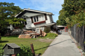
This addendum report provides an expanded geospatial analysis of the seismic vulnerability analysis first conducted in Geography 584 during the Spring 2025 semester (Chavez, 2025) as well as additional qualitative evaluation of seismic risk in National City. The initial scope of this project was to identify seismic vulnerability within residential structures built prior to 1980. This addendum expands that scope to include an inventory of vulnerability characteristics across all parcels in the city, regardless of residential status. To complete this inventory of vulnerability factors, this project used a parcel-level scale to classify properties based on structural, geophysical, and socioeconomic factors. Structural characteristics included structure type, presence of a crawlspace, year built, and number of floors. These characteristics were combined with geophysical characteristics, including liquefaction risk, soil type, and slope angle. Additionally, the Social Vulnerability Index compiled by the U.S. Census Bureau and the Centers for Disease Control provided the socioeconomic index. Integrating these three classifications yielded a combined vulnerability index. The results of this analysis are intended to assist emergency operations managers and emergency responders in planning, deploying, and helping local residents recover from a major seismic event. The stated purpose was to identify residential structures vulnerable to significant damage or collapse during a seismic event. The end result provided structural vulnerability factors for every parcel in the city, with the exception of US military facilities.
Site Search:
Using GIS to Assess Seismic Vulnerability in National City: Addendum
Atsushi Nara
Metrics
- University San Diego State University
- Program The Sage Project
- Sustainable Development Goals 09 Industry Innovation and Infrastructure, 10 Reduced Inequalities, 11 Sustainable Cities and Communities
- University Department Geography
- Lead Local Gov / Community Partner Org Name National City