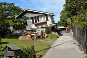
This report presents a comprehensive assessment of seismic vulnerability in National City, completed by students from San Diego State University’s Geography 584 (GIS Applications) course in collaboration with the Sage Project and the City of National City. Using Geographic Information Systems (GIS), the project combined a parcel-level inventory of residential buildings with geophysical and social data to identify patterns of vulnerability across neighborhoods. Key factors analyzed included soil type, slope, and liquefaction risk, along with the Centers for Disease Control and Prevention/Agency for Toxic Substances and Disease Registry’s Social Vulnerability Index. These elements were incorporated into a Weighted Linear Combination model to produce a composite vulnerability score for each parcel in National City. Due to time constraints, the final analysis in this report was conducted for all parcels citywide; however, future work will refine the queries to focus specifically on residential parcels. The results highlight where physical hazards and social vulnerabilities overlap, providing city officials with a data-driven foundation for hazard mitigation planning, infrastructure retrofits, and targeted community outreach.
Site Search:
Using GIS to Assess Seismic Vulnerability in National City
Atsushi Nara
Metrics
- University San Diego State University
- Program The Sage Project
- Sustainable Development Goals 09 Industry Innovation and Infrastructure, 10 Reduced Inequalities, 11 Sustainable Cities and Communities
- Population Type Residents
- University Department Geography
- Lead Local Gov / Community Partner Org Name National City